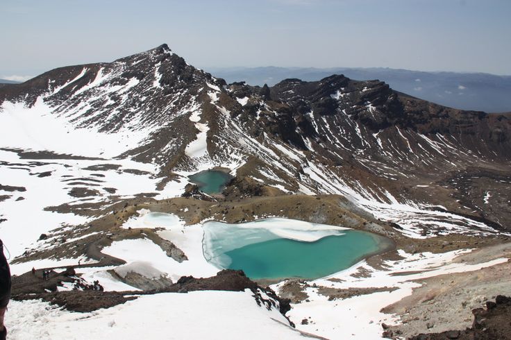
Tongariro National Park-New Zealand
Tongariro National Park – New Zealand is the oldest national park in New Zealand, located in the central North Island of New Zealand. It has been acknowledged by UNESCO(United Nations Educational, Scientific and Cultural Organization) as one of the 28 mixed cultural and natural World Heritage Sites.
Tongariro National Park (New Zealand) was the 4th national park established in the world. The active volcanic mountains Ruapehu, Ngauruhoe, and Tongariro are located in the center of the park.

Tongariro National Park-New Zealand
There are a number of Maori religious sites within the park and the summits of Tongariro, including Ngauruhoe and Ruapehu, are tapu (sacred).The park includes many towns around its boundary including Ohakune, Waiouru, Horopito,Pokaka, Erua, National Park Village, Whakapapa skifield and Turangi.
The Tongariro National Park is home to the famed Tongariro Alpine Crossing, widely regarded as one of the world’s best one-day hikes.
Location of Tongariro National Park – New Zealand
This Beautiful Tongariro National Park covers approximately 795.98 km2 stretching between 175° 22′ and 175° 48′ East and 38° 58′ and 39° 25′ South in the heart of the North Island in New Zealand . It is just a few Km west-southwest of Lake Taupo. It is 330 km south of Auckland by road, and 320 km north of Wellington. It contains a considerable part of the North Island Volcanic Plateau. Directly to the east stand the hills of the Kaimanawa range. The Whanganui River rises within the park and flows through Whanganui National Park to the west.
Most of the park is located in the Ruapehu District (Manawatu-Wanganui Region), although the northeast is in the Taupo District (Waikato Region, or Hawke’s Bay region to the north).
Dimension of Tongariro National Park – New Zealand
Tongariro National Park stretches around the massif of the 3 active volcanoes Mount Ngauruhoe, Mount Ruapehu, and Mount Tongariro. The Pihanga Scenic Reserve, containing Lake Rotopounamu, Mount Pihanga and the Kakaramea-Tihia Massif, though separate from the main park area, is still part of the Tongariro national park .
On the park borders are the towns of Turangi, National Park Village and Ohakune. Further away are Waiouru and Raetihi. Within the park borders, the only settlements are the tourism-based village at Whakapapa Village which consists solely of ski accommodation. Two Maori kainga (settlements) Papakai and Otukou are not part of the park but lie on the shores of Lake Rotoaira between the Pihanga Scenic Reserveand the main park area.
The bulk of Tongariro National Park is surrounded by well-maintained roads that roughly follow the park borders and provide easy access. In the west, State Highway 4 passes National Park village, and in the east, State Highway 1, known for this stretch as the Desert Road, runs parallel to the Tongariro River. State Highway 47 joins these two highways to the north of much of the park, although it bisects the Pihanga Scenic Reserve. The southern link is State Highway 49. The North Island Main Trunk railway from Auckland to Wellington passes through Tongariro National Park village.
Climate Condition
Like the whole of New Zealand, Tongariro National Parkof the New Zealand is situated in a temperate zone. The prevailing westerly winds gather water over the Tasman Sea. As the volcanoes of Tongariro National Park are the first significant elevations that these winds encounter on the North Island of New Zealand, besides Mount Taranaki, rain falls almost daily. The east-west rainfall differences are not as great as in the Southern Alps, because the three volcanoes do not belong to a greater mountain range, but there is still a noticeable rain shadow effect with the Rangipo desert on the Eastern leeward side receiving 1,000mm rain PA . At Whakapapa Village (1119m) the average annual rainfall is about 2200 mm, in Ohakune (610m) about 1250 mm and in higher altitudes, such as Iwikau Village (1770m), about 4900 mm. In winter there is snow to about 1500 m. Temperatures vary dramatically, even within one day. In Whakapapa, they can fall below the freezing point all year round. The average temperature is 13 °C, with a maximum of 25 °C in summer and a minimum of -10 °C in winter. In some summers the summits of the three volcanoes are covered with snow; on top of Mount Ruapehu, snow fields can be found every summer and the summit is glaciated.

Tongariro National Park-New zealand
History of Tongariro National Park – New zealand
In 1886 A.D in order to prevent the selling of the mountains to European settlers, the local Ngati Tuwharetoa iwi had the mountains surveyed in the Native Land Court and then set aside (whakatapua) as a reserve in the names of certain chiefs one of whom was Te Heuheu Tukino IV (Horonuku), the most significant chief of the Māori Ngati Tuwharetoa iwi. Later the peaks of Mount Tongariro, Mount Ngauruhoe, and parts of Mount Ruapehu, were conveyed to The Crown on 23 September 1887 A.D, on condition that a protected area was established there.
This 26.4 km2 area was generally considered to be too small to establish a national park after the model of Yellowstone National Parkin Wyoming, United States, and so further areas were acquired. When the Parliament of New Zealand passed the Tongariro National Park Act in October 1894 A.D, the park covered an area of about 252.13 km2, but it took until 1907 to acquire the land. When the Act was renewed in 1922 A.D, the park area was extended to 586.8 km2. Further extensions, especially Pihanga Scenic Reserve in 1975 A.D, enlarged the park to its current size of 795.98 km2. The last modification to the Act was passed in 1980 A.D. Tongariro National Park has been under the control of the New Zealand Department of Conservation since the creation of the department in 1987 A.D.
The first activities in the young Tongariro National Park were the construction of tourist huts at the beginning of the 20th century. But it was not before opening of the railway in 1908 and the building of roads in the 1930s that a significant number of people visited the park. The second Tongariro National Park Act, in 1922 A.D, started some active conservation efforts, but it was not until 1931 that the first permanent park ranger began work. Road construction into Whakapapa valley had already begun in the 1920s. The first ski hut was built in 1923 A.D at an elevation of 1770 m, thereafter a road, and, in 1938, a ski lift in the area. This early tourist development explains the rather uncommon existence of a permanently inhabited village and fully developed ski area within a national park. The hotel Chateau Tongariro, which is still the centre of Whakapapa today, was established in 1929 A.D.
In the early 20th century, park administrators introduced heather to the park, for grouse hunting. Grouse were never actually introduced, but the heather is sprawling, threatening the ecological system and endemic plants of the park. Efforts are being made to control the plant’s spread, however complete eradication seems unlikely.


